The Norman Way

Heritage route in Wexford

Menu

Skip to content
  • Welcome
  • Along the Route
    • Rosslare Harbour
    • Lady’s Island
    • St Iberius’ Church
    • Tacumshane Windmill
    • St Catherine’s Church
    • Sigginstown Castle
    • Ishartmon Church
    • Tomhaggard
    • Ballyhealy Castle
    • Grange Church
    • Kilmore Quay
    • Killag Church
    • Duncormick
    • St Imoge’s Church
    • Coolhull Castle
    • The Bannow Font
    • Bannow
    • The Little Sea
    • Tintern Abbey
    • Saltmills
    • Fethard Castle
    • Baginbun
    • Loftus Hall
    • Slade Harbour
    • Hook Lighthouse
    • St Dubhán’s Church
    • Templetown
    • Duncannon Fort
    • Ballyhack
    • Dunbrody Abbey
    • Kilmokea
    • JFK Arboretum
    • Kennedy Homestead
    • Stokestown Castle
    • St Mary’s Church
  • Stories
    • Rosslare Harbour
    • Lady’s Island
    • St Iberius’ Church
    • Tacumshane Windmill
    • St Catherine’s Church
    • Sigginstown Castle
    • Ishartmon Church
    • Tomhaggard
    • Ballyhealy Castle
    • Grange Church
    • Kilmore Quay
    • Killag Church
    • Duncormick
    • St Imoge’s Church
    • Coolhull Castle
    • The Bannow Font
    • Bannow
    • The Little Sea
    • Tintern Abbey
    • Saltmills
    • Fethard Castle
    • Baginbun
    • Loftus Hall
    • Slade Harbour
    • Hook Lighthouse
    • St Dubhán’s Church
    • Templetown
    • Duncannon Fort
    • Ballyhack
    • Dunbrody Abbey
    • Kilmokea
    • JFK Arboretum
    • Kennedy Homestead
    • Stokestown Castle
    • St Mary’s Church
  • More…
    • Contact
    • Email Newsletter
    • Cycling the Route
    • Further reading
    • Primary Teacher resource
    • The Norman Way on Amazon Alexa
    • Biography of the Norman Way project
    • Useful Links
    • Privacy Policy

Duncannon Fort

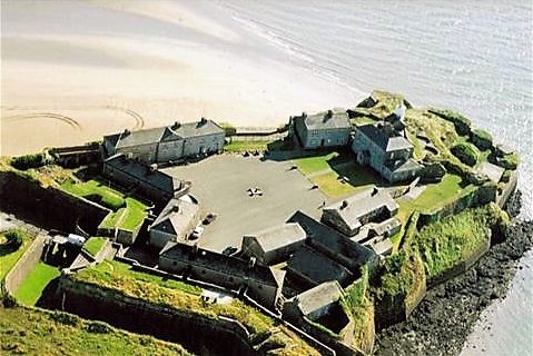
The name ‘Duncannon’ comes from old Irish and means ‘the fort of the son of Conan’, which points to the fact that a promontory fort was located here  prior to the arrival of the Normans.

Duncannon Fort
The military-minded Normans saw the value of this location in terms of defending the local coastline on one of the busiest shipping routes to and from Ireland. Early maps show a medieval tower house standing on the promontory where the fort is now located.

Over the centuries, and in response to foreign threats ranging from the Spanish Armada to the First and Second World Wars, the defences here grew to become the substantial fortress you see today. Duncannon Fort was used by the Irish Defence Forces until the 1980s.

The Christian Diet of the Normans
The Normans maintained a fish weir here at Duncannon. Fish weirs have been used in Ireland since the prehistoric period. A stone wall or timber fence was used to direct fish swimming up or down river into a basket-like trap or net placed at a suitable point in the water.

Fish weirs became particularly important after the introduction of Christianity. During the medieval period Christian rules dictated that meat could not be eaten on certain weekdays or during the 40 days of Lent. Fish, for those people who could afford it, became an important alternative to meat at these times.

–
To find Duncannon Fort…
Type these coordinates into Google:
52.221031, -6.933474

–

To the West along the Way lies…
Ballyhack

To the East along the Way lies…  
Templetown

–

Logos banner
Facebooktwitterredditpinterestlinkedinmail
Widgets

Recent Posts

  • St. Iberius’ Church Relic – Saved from Cromwell but Lost for 200 years…
  • The Medieval Church in Tomhaggard
  • The Lost Language of Yola
  • King Arthur’s final resting place…
  • Your Stories from The Norman Way

Recent Comments

    Archives

    • January 2017
    • December 2016
    • November 2016
    • August 2016

    Categories

    • local knowledge

    Meta

    • Log in
    • Entries feed
    • Comments feed
    • WordPress.org
    Proudly powered by WordPress | Theme: Illustratr by WordPress.com.